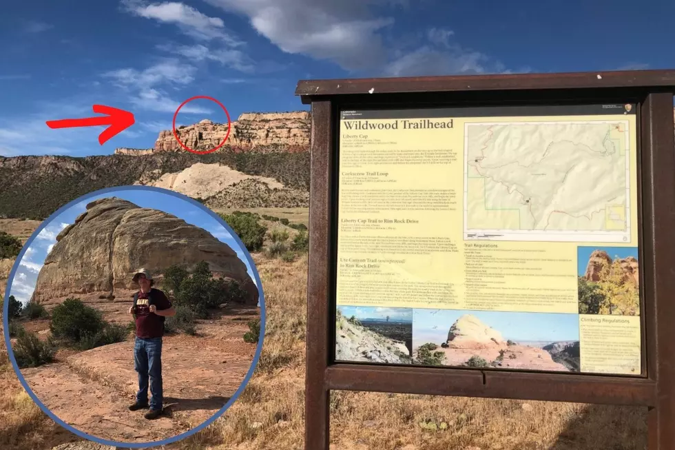
Amazing Views Reward Hikers Who Make It Up Grand Junction’s Liberty Cap
Grand Junction's Wildwood Trailhead is the gateway to some of western Colorado's more challenging hikes with amazing views.
Home to the Liberty Cap trailhead, the Wildwood trails are located by taking Redlands Parkway to Broadway to Wildwood Drive. Turn into the trailhead and go around the corner to find the small parking area. Lock your car.

What Feature is at the top of the Liberty Cap Trail?
The dome formation that is the Liberty Cap is a 160-million-year-old sand dune according to the marker at the top of the trail. This hike is popular for its incredible views and the experience of hiking switchbacks and ledges around 6000 feet.
What is the Elevation of Grand Junction's Liberty Cap?
The Liberty Cap trail starts out around 4700 feet and climbs to an elevation of around 5959 feet. The trail is a 3-mile loop but your legs will tell you it feels twice as long by the time you come back down. This hike takes some effort but is totally worth it. I saw three or four people running this trail over the weekend which seems impossible to me.
How Difficult is the Liberty Cap Trail?
This trail is incredibly fun despite most people breathing pretty heavily at times. I would say that the trail is difficult if you are new to hiking. I would call it moderate if you have been at this hobby a while. It was my first time on this trail, and I was definitely feeling it in my knees coming down the steep incline. I had to laugh because the nice easy mile from the base of the climb to the parking area seemed like 10 miles after climbing up and down the Cap. Go enjoy!
Hike the Amazing 1100 Foot Climb to Grand Junction's Liberty Cap
Gallery Credit: Wes Adams
MORE HIKING: Western Colorado's Best Hikes: The Grand Mesa's Trail to Lost Lake
Gallery Credit: Wes Adams
KEEP GOING: K1 and Devils Trail: The Hike to Cowboy Hat Tower in Fruita, Colorado
Gallery Credit: Wesley Adams
More From ESPN Western Colorado